
Delhi Meerut Metro: Connecting the Capitals with Speed and Efficiency
 22-May-2023
The Delhi Meerut Metro, officially known as the Delhi Meerut Regional Rapid Transit System (RRTS), is an ambitious project aimed at improving connectivity between the national capital Delhi and the city of Meerut. This rapid transit system is set to revolutionize the way people travel in the region, offering a host of features, an extensive route map, and a timeline that promises convenience and efficiency for commuters. Let's explore the key aspects of the Delhi Meerut Metro in detail.
Features of Delhi Meerut Metro
India's First RRTS Corridor:
The Delhi Meerut Metro is the first Regional Rapid Transit System (RRTS) corridor in India, designed to provide high-speed connectivity between the two cities.
The project is a part of the Make in India initiative and has been developed by the National Capital Region Transport Corporation (NCRTC).
Length and Stations:
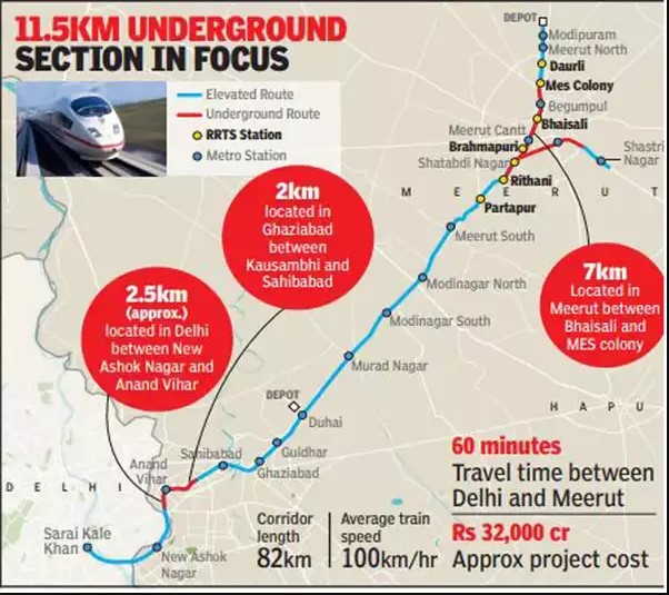
The metro line spans approximately 82.15 kilometers, connecting Sarai Kale Khan in Delhi to Modipuram in Meerut.
The line consists of 22 stations, excluding two depots: Duhai and Modipuram.
High Speed and Safety:
The Delhi Meerut Metro boasts an average speed of 100 km/h and a top/design speed of 180 km/h, ensuring faster and efficient travel.
The metro adheres to all international safety standards, guaranteeing a secure commuting experience.
Reduction of Traffic and Air Pollution:
The metro is expected to reduce traffic congestion in the region, offering a sustainable and eco-friendly mode of transportation.
By providing a convenient alternative to private vehicles, the metro aims to reduce air pollutants, including particulate matter, nitrogen oxide, hydrocarbons, and carbon monoxide.
Also Read: Escape Discrimination While House Hunting in Delhi NCR
Delhi Meerut Metro Route Map:
The route map of the Delhi Meerut Metro encompasses 22 stations and two depots.
The stations along the route include Sarai Kale Khan - Nizamuddin, New Ashok Nagar, Anand Vihar, Sahibabad, Ghaziabad, Guldhar, Duhai, Murad Nagar, Modi Nagar South, Modi Nagar North, Meerut South, Partapur, Rithani, Shatabdi Nagar, Brahmapuri, Meerut Central, Bhaisali, Begum Pul, MES Colony, Daurli, Meerut North, and Modipuram.
Expected route map of Delhi Meerut Metro (Source:Times of India)
Delhi Meerut Metro Fare:
The exact ticket prices for the Delhi Meerut Metro are yet to be announced, but it is expected that an EMV-based open-loop Automated Fare Collection (AFC) system will be installed for fare collection.
Delhi Meerut Metro Timeline:
The construction and operational timeline for the Delhi Meerut Metro is as follows:
June 2023: The 17 km priority stretch between Sahibabad and Duhai, with four stations, is expected to commence operations.
2025: The entire 82.15 km stretch from Duhai to Modipuram, including all stations and depots, is slated to be operational.
Also Read: Top Locations For Renting a Commercial Space in Delhi NCR
Conclusion:
The Delhi Meerut Metro is a groundbreaking project that promises to transform the way people commute between Delhi and Meerut. With its high-speed connectivity, extensive route map, and emphasis on safety and convenience, this metro system will significantly reduce travel time and alleviate traffic congestion in the region. As the first RRTS corridor in India, the Delhi Meerut Metro sets the stage for future developments and lays the foundation for efficient and sustainable transportation systems. So get ready to experience a new era of travel with the Delhi Meerut Metro!
